| 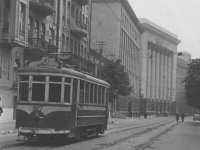 | Prewar route 18 used to run from Bessarabka
upwards via Kruglouniversitetskaya (the steepest tram incline ever in Kiev)
towards the neighborhood of Lipki and Kievo-Pecherskaya Lavra (Monastery on the Caves).
This car rests empty, with the bow collector lowered in the wrong direction.
The time is most likely September 1941 or spring 1942.
Note the poor shape of the asphalt around the rails.
Several people, probably guards, can be seen by the building in the background
(former Headquarters of Kiev Military District, then Central Committee
of the Communist Party of Ukraine, nowadays Presidential Administration).
[SM collection, 1940's] |
|
| 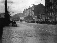 | The corner of Bolshaya Vasilkovskaya (Krasnoarmeyskaya)
and Zhilyanskaya. The trolleybus catenary is still intact.
On the rails far away, a train of several tramcars is visible;
it's hard to tell whether it is moving or standing still due to lack of power.
[SM collection, 1941] |
|
| 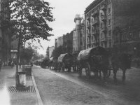 | Here we see a totally different means of transport moving
along tram tracks. One can assume these to be German troops still entering Kiev,
since the caravan is coming from the west.
The place is easily recognizable: Saksaganskogo between Pankovskaya and Tolstogo.
To the left from this frame is the Lesya Ukrainka museum.
[SM collection, 1941] |
|
| 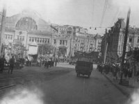 | The stub terminus of route 7 at Bessarabka,
where the Bulvar Shevchenko line towards Svyatoshin begins.
On the left-hand side is the connection used by cars to switch tracks.
This place looks quite similarly even today, except that the stands
on the boulevard have given way to the granite stairs of the Lenin monument...
and, of course, it is some 60 years since the tram tracks were lifted.
[SM collection, 1940's] |
|
| 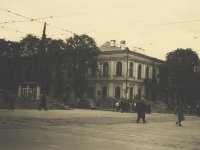 | The corner of Bulvar Shevchenko and Vladimirskaya (behind us
is Shevchenko Park). Piles of dirt on sidewalks are likely the remnants of barricades.
It is unknown whether trams run, but people mostly walk...
[SM collection, 1940's] |
|
| 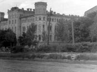 | Further along the boulevard (Rownowerstrasse at the time)
is another place which hasn't much changed. This is at the corner of the
boulevard and the present-day Mikhaila Kotsyubinskogo St.
[IRJ collection, 1940's] |
|
| 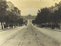 |
NEW
At the intersection of Bulvar Shevchenko and Bezakovskaya (nowadays Kominterna),
where there used to be a monument to Count Bobrinsky and today is a monument to Schors,
tracks to Vokzal (railway station) branched off. This picture is taken
from a spot slightly below that branching, looking towards Vokzal.
[SM collection, 1940's] |
|
| 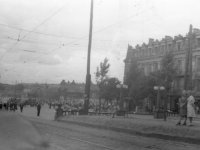 | Having passed Bezakovskaya, the line descends towards Yevbaz
(Yevreysky Bazar, i.e., Jewish Market).
Immediately we see huge crowds. The market was the place where people
bought, stole, got to know the news...
[IRJ collection, 1940's] |
|
| 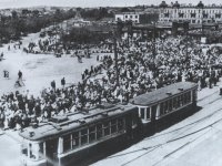 | Trams at Yevbaz, on the line which, at the time,
ran from Dmitrievskaya straight into Saksaganskogo.
Bulvar Shevchenko, which becomes Brest-Litovskoe Shosse, is on our left.
Today the circus building is where the market used to be, while the
building in the background is still there (an air ticket office is there now).
The photo is in the book by D. Malakov
This was Yevbaz, and then Ploscha Peremogy,
Kiev, 2004, p. 86 (in Ukrainian).
[1942] |
|
| 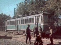 | Further along the boulevard, in the block between Yevbaz
and present-day Vozduhoflotsky Bridge (this block is now a part of Prospekt Pobedy),
a photo masterpiece is awaiting us.
The author was a serviceman with Propaganda Kommando 637 of the infamous
6th German Army (recall Stalingrad).
For details, see Babiy Yar: Man, Power, History,
Kiev, 2004, Book 1, p. 165 (in Russian).
The POWs and a guard are depicted against the background of Pullmann #1023
from route 7. This car, too, is motionless: service is to resume in more than
two weeks.
[Johannes Hähle, 01.10.1941] |
|
| 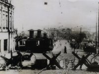 | The picture was taken by Acme Radiophoto and wired from Stockholm
to New York. These are German barricades; it is known that in October 1943,
in the face of a Soviet assault that ended in the liberation of Kiev,
the parts of town closest to the Dnieper were declared "war zone",
fenced, and evacuated.
There is some doubt as to the place, but supposedly it is the same Yevbaz
(we stand on Bulvarno-Kudryavskaya and look down).
[SM collection, 30.10.1943] |
|
| 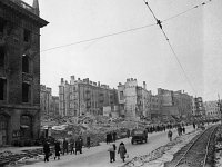 | NEW
After the liberation of Kiev, temporary tram trackage was installed
on Kreschatik, in order to facilitate building supplies and garbage disposal.
The photo depicts the results of a series of explosions set up by
Soviet agents in 1941...
This image and the following one are from the Museum Berlin Karlshorst publication "Rodina i front".
Copies have been kindly supplied by Prof. Alan Kimball, University of Oregon, USA.
[Ivan Shagin, 1944] |
|
| 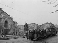 | NEW
This is how people rode the tram in a liberated Kiev...
The place is Vladimirskaya, the building on the left is the Kiev Opera.
The photos are dated 1943; however, judging by the look of the snow piles,
the author believes that the spring of 1944 is a more plausible version.
[Ivan Shagin, 1944] |
|
| 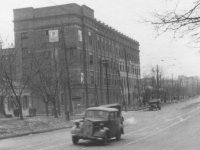 | Puzzle #1 (I don't know the answer). Where is this?
[IRJ collection, 1940's] |
|
| 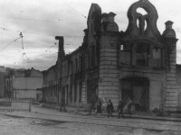 | Puzzle #2 (the same). Where is this?
[IRJ collection, 1940's] |
|